
Southern Utah’s San Juan River once snaked across a nearly flat plain. Over time, the river’s current cut into its banks, crafting an increasingly sinuous channel. Later, while tectonic forces raised the level of the land by several thousand feet, the river continued to follow its original course. Carving through the emerging plateau, it dug deeper into the underlying bedrock to create an entrenched meander. This geologic feature has occurred in other places, though not with the dramatic profile of San Juan’s “goosenecks.”
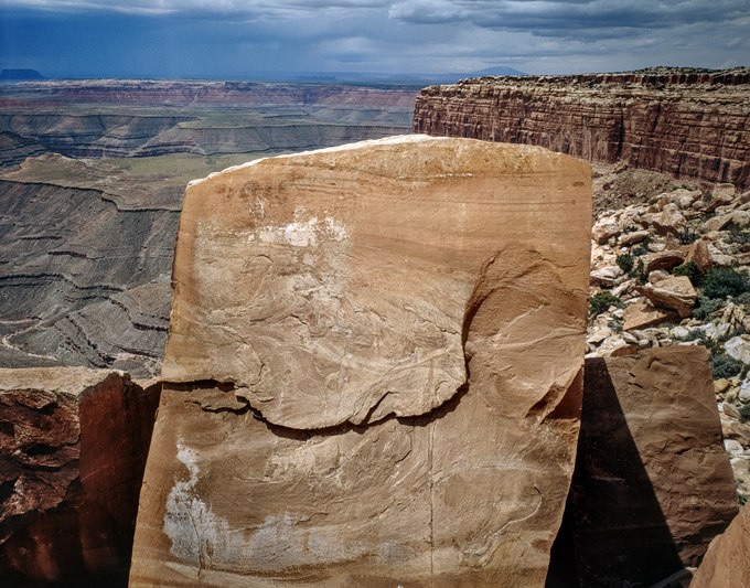
Cedar Mesa overlooks the river two thousand feet above, and Muley Point, the southern neck of this plateau, provides a sweeping view of the surrounding canyonlands. Capped by a thick, flat layer of quartz sandstone from the air, this promontory looks almost like a shelf of bread loaves, each with a rounded top that compactly abuts one another. Their cleanly sculpted appearance along Muley Point’s cliff face, where they break off, has led to conjecture that they were built by an ancient civilization. Though this type of feature is rare, geologists assure us that its making is, in fact, geological.
Fractured by the land’s uplift, the mineral composition of this sedimentary rock favored cleaving along right angles. Over time and today, as the river erodes the plateau’s base, rectangular-shaped boulders peel off Muley Point like the one shown in the photograph. Eventually, this massive block will tumble, break apart, dissolve into sand, and be carried downstream to Lake Powell. There, the captured river’s sediment will accumulate on the bottom of the lake to become, once again, sandstone.
Location research and commentary by James Baker.