
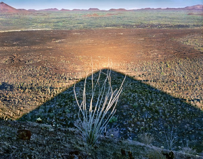
Occasionally, identifying the location of my photographs can be challenging, especially when preparing to write about a remote area. After searching Google Maps, I discovered I had set up my view camera at 31.897 degrees north and 113.368 degrees west, atop the crest of El Cono Mayo's volcanic cone, a few hundred feet above this lava plain.
Located in northwestern Mexico, the Sierra Pinacate is a lofty moonscape filled with volcanic peaks, lava flows, craters, and cinder cones formed over the past five million years. Designated as an international biosphere reserve – a conservation zone of landscapes, ecosystems, and species – it remains a rugged, uninhabited terrain surrounded by a vast sea of windblown dunes. This region supported an Indigenous population twenty thousand years ago during a cooler, wetter climate. Today, despite only six inches of annual rainfall, these isolated highlands continue to host a variety of life forms, many of which are endemic.
Ocotillo, meaning "little pine" in Mexican Spanish, is classified as a desert plant. However, it was initially regarded as a pine (Ocote) because its stalks produce a similar resin that Indigenous peoples once used. The plant resembles a thorny bouquet of dried branches; its lower stems remain green throughout the year, while red flowers bloom from their tips following the spring and summer rains.
From the rim of El Cono Mayo, one can gaze westward across gardens of ocotillo, creosote bushes, and cacti bordering a lava field that once flowed from this cinder cone. Buttes, crater rims, and distant mountains punctuate the horizon. The black basaltic flow takes on a reddish hue as it reflects the light of the rising sun’s rays.
Location research and commentary by James Baker.