
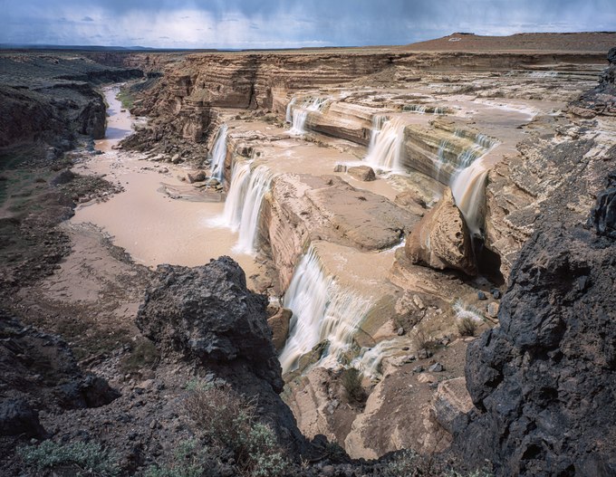
Grand Falls in northeastern Arizona lies within a remote basin traversed by the Little Colorado River. The river originates from the snowy peaks of the White Mountains and is fed by natural springs along its 300-mile journey before merging with the Colorado River in the heart of the Grand Canyon. The river's flow varies in intensity and color with the seasons. Also known as "Chocolate Falls," during early spring, rainfall and snowmelt wash muddy sediment from tributaries, tinting the river ochre. An emerald-blue trickle, dyed by travertine-rich spring water, runs over the falls during dry spells.
At one time, my camera's location would have been 200 feet above a canyon that once served as the river's channel. When I took this image decades ago, I stood atop a lava flow that, 20,000 years earlier, had filled its historic gorge. The hard, impermeable lava forced the Little Colorado to carve a new route around the volcanic rock, causing it to cascade over a section of the canyon wall seen on the right side of the photograph.
Across the river, on a butte, lies the hillside letter "G," designating "Grand Falls." That has since vanished, along with the open road to the falls. In 2023, tribal residents closed the area. Like other ancestral sites in the West, rapidly increasing tourism has made places such as Grand Falls unsafe and unmanageable. The river sustains local agriculture and holds sacred significance for the ancient beliefs of the native population. Zuni farmer Jim Enote described the river as "an umbilical cord that connects us back to our emergence place, the Grand Canyon."