
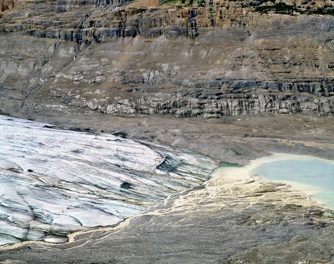
Formed 240,000 years ago, the Columbia Icefield spans a 10,000-foot-high plateau atop the provincial border between Alberta and British Columbia. It is the largest icefield in the Rocky Mountains and the source of several glaciers. The Saskatchewan Glacier is the largest among them, extending eight miles and dropping a mile in elevation to its terminus.
The glacier’s size has fluctuated, expanding and shrinking due to changes in the climate. After the last ice age, the Saskatchewan Glacier reached its largest extent in the 19th century. Since then, its toe has retreated a mile, and in recent decades, its volume has decreased by about one percent annually. At one time, the glacier scraped against the base of the cliffs at the top of the photograph, three hundred feet above its current surface. Today, melting ice exceeds snow accumulation, causing trees, animal remains once trapped in the glacier, and rocks, sand, and clay to be deposited at its toe. At its current melt rate, the glacier could disappear entirely within another century.
Hiking alone to the glacier’s terminus, the remote and vast terrain seemed overwhelming. I felt small, vulnerable, and initially questioned whether it was wise to proceed. Navigating the trailless valley, I followed a thundering river, scrambled over and around boulder piles, and climbed unstable slopes until I reached this elevated view. What struck me most in this mid-summer scene was the sound of water: multiple water channels flowing on top of, and originating from, the glacier's base, flooded a silt-filled pond; the source of the Saskatchewan River, which then flows 1600 miles eastward to Canada’s Hudson Bay and the Atlantic Ocean.